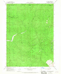
1966 Map of High Divide
USGS Topo · Published 1968About this map
Siskiyou National Forest and Six Rivers National Forest converge at the state line in this mid-1960s survey of the northern California border. The High Divide forms a prominent ridge separating the drainage basins of the Winchuck River and Rowdy Creek to the west from the Smith River system to the east. This landscape is a record of early mountain transport and resource extraction, characterized by a network of primitive routes like the Wimer Road and Jeff Trail that once served remote mining operations. Local history is deeply tied to these extractive efforts, with the map identifying the Mountain View Mines, Alta Mine, and the Copper Creek Mine. A curious natural or cultural landmark, Hole-in-the-Ground, sits near a mine of the same name, while the Stone Corral (Site) suggests an earlier era of livestock management along these high ridges.
Find a feature on this map
35 named features on this map. Tap any name to fly to it.
Don’t see what you’re looking for? This feature index may not catch every label — zoom into the map to look around manually.
Map Details
Editions of this 1966 High Divide Map
This is the sole edition of this map. No revisions or reprints were ever made.
Other maps of this area

1917 · Kerby
USGS Topo · 1:125,000

1918 · Kerby
USGS Topo · 1:125,000

1922 · Preston Peak
USGS Topo · 1:125,000

1929 · Crescent City
USGS Topo · 1:125,000

1945 · Kerby
USGS Topo · 1:125,000

1945 · Gasquet
USGS Topo · 1:62,500

1945 · Point St. George
USGS Topo · 1:62,500

1948 · Weed
USGS Topo · 1:250,000

1949 · Eureka
USGS Topo · 1:250,000

1950 · Weed
USGS Topo · 1:250,000