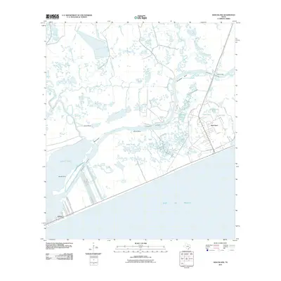
2010 Map of High Island
USGS Topo · Published 2010About this map
High Island stands as a prominent topographical feature on this Gulf Coast landscape, surrounded by the intricate marshlands and bayous of Galveston County. The 2010 geography reveals a complex intersection of natural hydrology and industrial infrastructure, where the Intracoastal Waterway cuts through the coastal wetlands. The area around High Island is defined by a series of specialized roads such as Oilfield Rd NW and Oilfield Rd SE, reflecting the region's historic ties to energy extraction. To the southwest, the community of Gilchrist sits on the narrow strip between the Gulf of Mexico and East Bay, marked by maritime access points like Faggard's Slip Rd and Waco Rd. Numerous water bodies, including Clay Bottom Pond, Smith Pond, and the meandering Onion Bayou, illustrate the transitional nature of this low-lying environment where freshwater systems meet the sea.
Find a feature on this map
34 named features on this map. Tap any name to fly to it.
Don’t see what you’re looking for? This feature index may not catch every label — zoom into the map to look around manually.
Map Details
Editions of this 2010 High Island Map
This is the sole edition of this map. No revisions or reprints were ever made.
Other maps of this area

1931 · High Island
USGS Topo · 1:24,000

1931 · Frozen Point
USGS Topo · 1:24,000

1933 · Frozen Point
USGS Topo · 1:31,680

1933 · Caplen
USGS Topo · 1:31,680

1943 · High Island
USGS Topo · 1:31,680

1943 · Frozen Point
USGS Topo · 1:24,000
1943 · Caplen
USGS Topo · 1:24,000

1943 · Sea Breeze
USGS Topo · 1:24,000

1945 · Sea Breeze
USGS Topo · 1:31,680

1950 · Houston
USGS Topo · 1:250,000