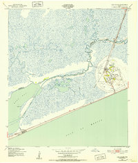
1943 Map of High Island
USGS Topo · Published 1952About this map
High Island stands as a prominent salt dome rising above the surrounding Lower Marsh, serving as a critical coastal hub during the early 1940s. This survey, based on 1942 aerial photography, documents the area's transition from a rail-dependent landscape to an energy-producing one, as the Gulf Colorado and Santa Fe railroad is already marked as abandoned while a dense network of Oil Wells, Oil Tanks, and a Water Tank dominates the town's immediate vicinity. Along the coast at Gilchrist, the proximity to the Gulf of Mexico is balanced by the industrial importance of the Intracoastal Waterway, which cuts through the marsh to facilitate maritime transport. The landscape is defined by intricate tidal features such as Mussel Point, Devils Elbow, and the meandering courses of Onion Bayou and East Bay Bayou. Local family history is rooted in the small settlement core, which includes a Cem and Clark Lake.
Find a feature on this map
30 named features on this map. Tap any name to fly to it.
Don’t see what you’re looking for? This feature index may not catch every label — zoom into the map to look around manually.
Map Details
Editions of this 1943 High Island Map
2 editions found
Other maps of this area

1931 · High Island
USGS Topo · 1:24,000

1931 · Frozen Point
USGS Topo · 1:24,000

1933 · Frozen Point
USGS Topo · 1:31,680

1933 · Caplen
USGS Topo · 1:31,680

1943 · High Island
USGS Topo · 1:31,680

1943 · Frozen Point
USGS Topo · 1:24,000
1943 · Caplen
USGS Topo · 1:24,000

1943 · Sea Breeze
USGS Topo · 1:24,000

1945 · Sea Breeze
USGS Topo · 1:31,680

1950 · Houston
USGS Topo · 1:250,000