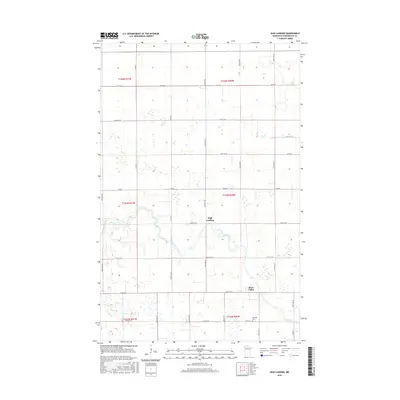
2016 Map of High Landing
USGS Topo · Published 2016About this map
High Landing and the neighboring settlement of River Valley anchor this portion of Pennington County, situated along the winding course of the Red Lake River. The landscape is defined by the transition from riparian corridors to precisely surveyed agricultural sections, reinforced by an extensive drainage system including County Ditch Number Thirty-nine A. This network of ditches and sections highlights the 21st-century efforts to manage the low-lying terrain for productive use. Local history is preserved at the Oak Park Cem near the southern boundary, while a grid of county roads like Co RD 91 and Co RD 6 facilitates movement through the rural townships. The map provides a clear view of the intersection between natural watercourses and the human-imposed geometry of the American Midwest.
Find a feature on this map
25 named features on this map. Tap any name to fly to it.
Don’t see what you’re looking for? This feature index may not catch every label — zoom into the map to look around manually.
Map Details
Editions of this 2016 High Landing Map
This is the sole edition of this map. No revisions or reprints were ever made.
Other maps of this area

1919 · Grit
USGS Topo · 1:62,500

1919 · Winsor
USGS Topo · 1:62,500

1954 · Bemidji
USGS Topo · 1:250,000

1954 · Roseau
USGS Topo · 1:250,000

1957 · Roseau
USGS Topo · 1:250,000

1957 · Bemidji
USGS Topo · 1:250,000

1958 · Bemidji
USGS Topo · 1:250,000

1958 · Roseau
USGS Topo · 1:250,000
1971 · Roland
USGS Topo · 1:24,000

1972 · Erie
USGS Topo · 1:24,000