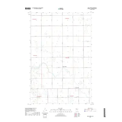
2019 Map of High Landing
USGS Topo · Published 2019About this map
The Red Lake River carves a winding path through this corner of Pennington County, defining the local geography and historical settlement pattern. The small community of High Landing sits at a strategic bend in the river, reflecting the importance of water access in this agricultural landscape. To the southeast, River Valley marks another point of habitation along the riverbanks, where the terrain transitions into the patterned wetlands and drainage systems typical of the region. A legacy of local families and early residents is preserved at Oak Park Cem in the southern portion of the quadrangle. The map also illustrates the extensive drainage infrastructure necessary for farming in this part of Minnesota, most notably the long stretch of County Ditch Number Thirtynine A.
Find a feature on this map
37 named features on this map. Tap any name to fly to it.
Don’t see what you’re looking for? This feature index may not catch every label — zoom into the map to look around manually.
Map Details
Editions of this 2019 High Landing Map
This is the sole edition of this map. No revisions or reprints were ever made.
Other maps of this area

1919 · Grit
USGS Topo · 1:62,500

1919 · Winsor
USGS Topo · 1:62,500

1954 · Bemidji
USGS Topo · 1:250,000

1954 · Roseau
USGS Topo · 1:250,000

1957 · Roseau
USGS Topo · 1:250,000

1957 · Bemidji
USGS Topo · 1:250,000

1958 · Bemidji
USGS Topo · 1:250,000

1958 · Roseau
USGS Topo · 1:250,000
1971 · Roland
USGS Topo · 1:24,000

1972 · Erie
USGS Topo · 1:24,000