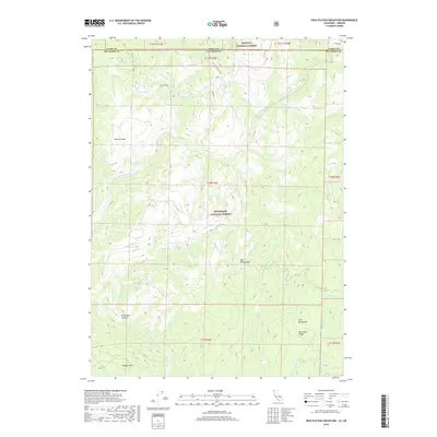
2018 Map of High Plateau Mountain
USGS Topo · Published 2018About this map
The North Fork Smith River carves a deep path through this borderland where Del Norte County, California meets Curry County, Oregon. This 2018 survey illustrates a landscape dominated by the overlapping boundaries of the Siskiyou National Forest and Six Rivers National Forest. The map captures a topography defined by steep ridges and canyons, including the prominent High Plateau Mtn and the uniquely named Peridotite Canyon. Transport through this wilderness is limited to legacy routes like Low Divide Rd and Wimer Rd, which follow the difficult contours of the land. In the southern portion of the sheet, Gasquet Mtn and Elk Camp Ridge stand as significant landmarks, while numerous tributaries such as Eighteenmile Cr and Twelvemile Cr drain into the primary river system, reflecting the complex hydrology of the Klamath Mountains.
Find a feature on this map
33 named features on this map. Tap any name to fly to it.
Don’t see what you’re looking for? This feature index may not catch every label — zoom into the map to look around manually.
Map Details
Editions of this 2018 High Plateau Mountain Map
This is the sole edition of this map. No revisions or reprints were ever made.
Other maps of this area

1917 · Kerby
USGS Topo · 1:125,000

1918 · Kerby
USGS Topo · 1:125,000

1922 · Preston Peak
USGS Topo · 1:125,000

1929 · Crescent City
USGS Topo · 1:125,000

1945 · Kerby
USGS Topo · 1:125,000

1945 · Gasquet
USGS Topo · 1:62,500

1945 · Point St. George
USGS Topo · 1:62,500

1948 · Weed
USGS Topo · 1:250,000

1949 · Eureka
USGS Topo · 1:250,000

1950 · Weed
USGS Topo · 1:250,000