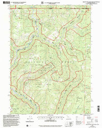
1997 Map of High Plateau Mountain
USGS Topo · Published 2001About this map
The Six Rivers National Forest and Siskiyou National Forest converge in this high-altitude landscape along the border of California and Oregon. Central to the area is High Plateau Mountain, a massive ridge defined by its complex geology and mining history. Several extraction sites are marked throughout these peaks, including the Big Boy Mine near the northern boundary and the Cleopatra Mine overlooking the North Fork Smith River. Farther south, Browns Mine and a designated Mill Site indicate a concentrated pocket of industrial activity near the headwaters of Diamond Creek. The terrain is characterized by deep incisions like Peridotite Canyon and prominent rises such as Gasquet Mountain and Cold Spring Mountain. The North Fork Smith Wild and Scenic River and its tributaries, including Stony Creek and Bear Creek, create a protected drainage system that remains largely primitive, with access provided by routes like the Camp Ridge Trail.
Find a feature on this map
29 named features on this map. Tap any name to fly to it.
Don’t see what you’re looking for? This feature index may not catch every label — zoom into the map to look around manually.
Map Details
Editions of this 1997 High Plateau Mountain Map
This is the sole edition of this map. No revisions or reprints were ever made.
Other maps of this area

1917 · Kerby
USGS Topo · 1:125,000

1918 · Kerby
USGS Topo · 1:125,000

1922 · Preston Peak
USGS Topo · 1:125,000

1929 · Crescent City
USGS Topo · 1:125,000

1945 · Kerby
USGS Topo · 1:125,000

1945 · Gasquet
USGS Topo · 1:62,500

1945 · Point St. George
USGS Topo · 1:62,500

1948 · Weed
USGS Topo · 1:250,000

1949 · Eureka
USGS Topo · 1:250,000

1950 · Weed
USGS Topo · 1:250,000