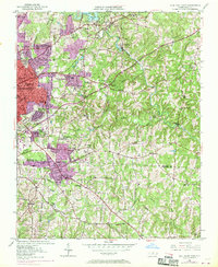
1950 Map of High Point East
USGS Topo · Published 1970About this map
High Point anchors the western edge of this landscape, its urban reach expanding during the mid-century as indicated by the 1968 aerial revisions. The industrial and academic character of the city is evident through institutions like High Point College and schools such as William Penn High Sch and Emma Blair Sch. Further south, the settlements of Archdale and Trinity mark the transition toward Randolph Co, where the terrain is punctuated by small rural communities like Bakertown and Allen Jay.
Find a feature on this map
58 named features on this map. Tap any name to fly to it.
Don’t see what you’re looking for? This feature index may not catch every label — zoom into the map to look around manually.
Map Details
Editions of this 1950 High Point East Map
3 editions found
Other maps of this area

1949 · High Point West
USGS Topo · 1:24,000

1950 · High Point East
USGS Topo · 1:24,000

1951 · High Point East
USGS Topo · 1:24,000

1951 · Guilford
USGS Topo · 1:24,000

1951 · Fair Grove
USGS Topo · 1:24,000

1951 · Greensboro
USGS Topo · 1:24,000

1953 · Raleigh
USGS Topo · 1:250,000

1953 · Charlotte
USGS Topo · 1:250,000

1953 · Winston-Salem
USGS Topo · 1:250,000

1953 · Greensboro
USGS Topo · 1:250,000