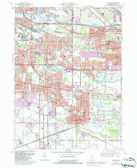
1968 Map of Highland
USGS Topo · Published 1986About this map
The Indiana Dunes National Lakeshore provides a preserved island of marshland amidst the dense industrial and suburban growth of Lake County during the late 1960s. This survey illustrates the rapid post-war expansion of Highland, Munster, and Griffith, where residential subdivisions and schools like the Purdue University Calumet Center were filling the spaces between long-established rail corridors. The landscape is defined by its complex drainage and transportation infrastructure, featuring the Grand Calumet River and Little Calumet River alongside the Indiana Harbor Belt RR and Conrail lines. Major interchanges such as the Indianapolis Blvd Interchange signal the era's heavy reliance on the growing highway system. The map also documents numerous local landmarks, from the Gary Municipal Airport and Wicker Park to several parochial institutions, including Our Lady of Perpetual Help Sch and St Marys Cem.
Find a feature on this map
122 named features on this map. Tap any name to fly to it.
Don’t see what you’re looking for? This feature index may not catch every label — zoom into the map to look around manually.
Map Details
Editions of this 1968 Highland Map
Other maps of this area

1892 · Calumet
USGS Topo · 1:62,500

1893 · Calumet
USGS Topo · 1:62,500

1900 · Toleston
USGS Topo · 1:62,500

1900 · Calumet
USGS Topo · 1:62,500

1901 · Calumet
USGS Topo · 1:62,500

1929 · Calumet Lake
USGS Topo · 1:24,000

1929 · Calumet City
USGS Topo · 1:24,000

1929 · Dyer
USGS Topo · 1:24,000

1930 · Dyer
USGS Topo · 1:24,000

1949 · Crete
USGS Topo · 1:62,500