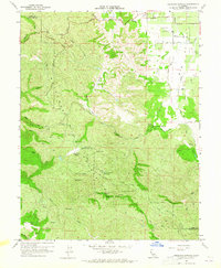
1959 Map of Highland Springs
USGS Topo · Published 1965About this map
The Mayacmas Mountains dominate this 1959 survey of the California landscape, where the rugged terrain of the Lake Co Mendocino Co boundary meets the agricultural potential of Big Valley. The map centers on the Highland Springs area, featuring the established Mineral Spring and Gaging Station along Highland Springs Creek. Human activity is concentrated in the northeast corner at the Big Valley Community Center and near the Lampson Airport, while the higher elevations are marked by remote landmarks like Cloverdale Peak, Monument Peak, and Gulliam Rock. Water resources are a primary focus of this topography, documented by the State of California Department of Water Resources. The network of drainage including Manning Creek, Adobe Creek, and Pieta Creek illustrates the complex watershed management necessary in these coastal ranges before more modern development reached the higher valleys like Donovan Valley and High Valley.
Find a feature on this map
57 named features on this map. Tap any name to fly to it.
Don’t see what you’re looking for? This feature index may not catch every label — zoom into the map to look around manually.
Map Details
Editions of this 1959 Highland Springs Map
3 editions found
Other maps of this area

1920 · Ukiah
USGS Topo · 1:62,500

1921 · Kelseyville
USGS Topo · 1:62,500

1938 · Lakeport
USGS Topo · 1:62,500

1938 · Hopland
USGS Topo · 1:62,500

1943 · Kelseyville
USGS Topo · 1:62,500

1943 · Hopland
USGS Topo · 1:62,500

1944 · Ukiah
USGS Topo · 1:62,500

1944 · Hopland
USGS Topo · 1:62,500

1947 · Santa Rosa
USGS Topo · 1:250,000

1949 · Santa Rosa
USGS Topo · 1:250,000