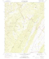
1969 Map of Hightown
USGS Topo · Published 1983About this map
Lantz Mountain and Monterey Mtn dominate this 1960s landscape along the West Virginia Virginia border, where the headwaters of the Jackson River and Back Creek begin their descent. This survey captures a rural highland corridor anchored by Hightown and Meadowdale, sitting between the protected lands of the Monongahela National Forest and George Washington National Forest. The map documents a classic Appalachian ridge-and-valley settlement pattern, with small family cemeteries and the Pisgah Ch situated in the more accessible gaps and hollows.
Find a feature on this map
56 named features on this map. Tap any name to fly to it.
Don’t see what you’re looking for? This feature index may not catch every label — zoom into the map to look around manually.
Map Details
Editions of this 1969 Hightown Map
3 editions found
Other maps of this area

1889 · Beverly
USGS Topo · 1:125,000

1892 · Beverly
USGS Topo · 1:125,000

1901 · Monterey
USGS Topo · 1:125,000

1922 · Spruce Knob
USGS Topo · 1:48,000

1922 · Cass
USGS Topo · 1:48,000

1922 · Durbin
USGS Topo · 1:48,000

1924 · Cass
USGS Topo · 1:62,500

1924 · Durbin
USGS Topo · 1:62,500

1924 · Spruce Knob
USGS Topo · 1:62,500

1941 · Monterey
USGS Topo · 1:62,500