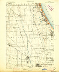
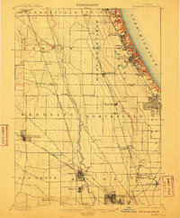
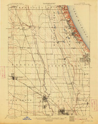
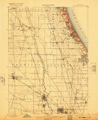
1900 Map of Highwood
USGS Topo · Published 1905About this map
Lake Michigan defines the eastern edge of this northern Illinois landscape at the close of the 19th century, where deep ravines cut through the bluffs to meet the shoreline. The region shows a transition from the established coastal communities of Highland Park and Glencoe to the agricultural prairie and emerging rail towns further inland. The Desplaines River flows southward through the center of the sheet, paralleled by a dense network of transit lines including the Chicago and Northwestern R.R. and the Chicago Milwaukee and St. Paul R.R. which fueled suburban growth. Geographically significant points like Fort Sheridan and the military outpost at Highwood sit prominently on the lakefront, while smaller inland hubs such as Shermerville and Aptakisic mark a rural era before mid-century development. This survey reveals the early spatial organization of townships like Deerfield and Northfield before they were fully absorbed into the suburban sprawl of the twentieth century.
Find a feature on this map
52 named features on this map. Tap any name to fly to it.
Don’t see what you’re looking for? This feature index may not catch every label — zoom into the map to look around manually.
Map Details
Editions of this 1900 Highwood Map
5 editions found
Other maps of this area

1889 · Chicago
USGS Topo · 1:62,500

1891 · Chicago
USGS Topo · 1:62,500

1891 · Riverside
USGS Topo · 1:62,500

1893 · Riverside
USGS Topo · 1:62,500

1899 · Evanston
USGS Topo · 1:62,500

1900 · Chicago
USGS Topo · 1:62,500

1900 · Riverside
USGS Topo · 1:62,500

1900 · Highwood
USGS Topo · 1:62,500

1901 · Riverside
USGS Topo · 1:62,500

1901 · Chicago
USGS Topo · 1:62,500