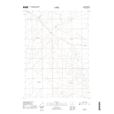
2017 Map of Hiland
USGS Topo · Published 2017About this map
Hiland sits at a geographic crossroads in Natrona County, where the high desert landscape is defined by the ephemeral waters of the S Fork Powder River and the winding course of Poison Cr. This 2017 U.S. Geological Survey topographic map captures a network of livestock-supporting infrastructure, characterized by numerous catchment basins including Dead Horse Reservoir, Neal Reservoir, and Adobe Reservoir. The presence of the Hiland Cem north of the main settlement provides a vital anchor for genealogists and local historians tracking the sparse population of this rural corridor. Significant terrain features such as Needles Eye Butte and the Sand Draw break the open plains, while local routes like Hiland Ln and Co Rd 212 connect the scattered homesteads and ranching tracts across the northern reaches of the t36n r88w and t36n r87w townships.
Find a feature on this map
19 named features on this map. Tap any name to fly to it.
Don’t see what you’re looking for? This feature index may not catch every label — zoom into the map to look around manually.
Map Details
Editions of this 2017 Hiland Map
This is the sole edition of this map. No revisions or reprints were ever made.
Other maps of this area
1952 · Arminto
USGS Topo · 1:24,000
1952 · Arminto SW
USGS Topo · 1:24,000
1952 · Arminto NW
USGS Topo · 1:24,000
1952 · Waltman NW
USGS Topo · 1:24,000
1952 · Waltman
USGS Topo · 1:24,000
1952 · Hiland
USGS Topo · 1:24,000
1952 · Ervay Basin
USGS Topo · 1:24,000

1955 · Arminto
USGS Topo · 1:250,000

1955 · Casper
USGS Topo · 1:250,000

1958 · Casper
USGS Topo · 1:250,000