
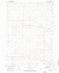
1952 Map of Arminto NW
USGS Topo · Published 1953About this map
Chicago Burlington and Quincy tracks through the high plains of Natrona County, following the natural corridor of Alkali Creek. This 1950s landscape reflects the ranching economy of the Missouri River Basin development era, punctuated by isolated homesteads like Todd Ranch and Sullivan Ranch. The drainage patterns are dominated by seasonal watercourses such as Poison Creek and Red Creek, where scattered Windmills and Corrals mark the essential infrastructure for livestock management in this arid environment. Surveyed shortly after aerial photography in 1949, the map provides a precise record of late-frontier Wyoming grazing lands, showing the locations of the Jack Ranch and Wight Ranch near the southern boundary. These named landmarks are vital for genealogists tracing family landholdings in the region before modern development or consolidation altered the rural township structure.
Find a feature on this map
13 named features on this map. Tap any name to fly to it.
Don’t see what you’re looking for? This feature index may not catch every label — zoom into the map to look around manually.
Map Details
Editions of this 1952 Arminto NW Map
2 editions found
Other maps of this area

1952 · Badwater
USGS Topo · 1:24,000

1952 · Arminto
USGS Topo · 1:24,000

1952 · Arminto SW
USGS Topo · 1:24,000

1952 · Madden
USGS Topo · 1:24,000

1952 · Lysite SE
USGS Topo · 1:24,000

1952 · Moneta SE
USGS Topo · 1:24,000

1952 · Hiland
USGS Topo · 1:24,000

1952 · Badwater SE
USGS Topo · 1:24,000

1955 · Arminto
USGS Topo · 1:250,000

1958 · Arminto
USGS Topo · 1:250,000