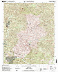
1995 Map of Hildreth Peak
USGS Topo · Published 2000About this map
Hildreth Peak rises over the backcountry of the Los Padres National Forest, marking a landscape where the Santa Ynez River meets several significant mountain tributaries. In the mid-1990s, this area of Santa Barbara County remained largely a wilderness defined by its ranching and forest management history. The map highlights the Los Prietos y Najalayegua Grant, a large tract where human activity is centered on sites like the Ogilvy Ranch and the Pendola Guard Station. Water sources are central to the terrain, including Agua Caliente Creek, Mono Creek, and the isolated Little Caliente Spring. Access into these canyons is provided by the Romero Road and Camuesa Road, connecting lower river points like P-Bar Flats and Middle Santa Ynez to the higher elevations, while a landing strip near Pie Canyon indicates the necessity of aerial access in this complex environment.
Find a feature on this map
25 named features on this map. Tap any name to fly to it.
Don’t see what you’re looking for? This feature index may not catch every label — zoom into the map to look around manually.
Map Details
Editions of this 1995 Hildreth Peak Map
This is the sole edition of this map. No revisions or reprints were ever made.
Other maps of this area

1902 · Santa Ynez
USGS Topo · 1:125,000

1903 · Mt. Pinos
USGS Topo · 1:125,000

1904 · Ventura
USGS Topo · 1:62,500

1905 · Santa Ynez
USGS Topo · 1:125,000

1941 · Ventura
USGS Topo · 1:62,500

1942 · Little Pine Mountain
USGS Topo · 1:24,000

1943 · Big Pine Mountain
USGS Topo · 1:31,680

1943 · Rancho Nuevo Creek
USGS Topo · 1:24,000

1943 · Old Man Mountain
USGS Topo · 1:24,000

1943 · Hildreth Peak
USGS Topo · 1:24,000