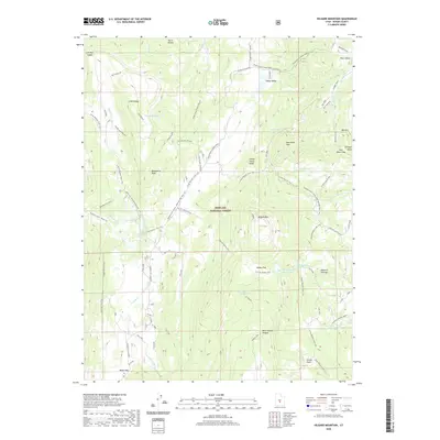
2020 Map of Hilgard Mountain
USGS Topo · Published 2020About this map
Fishlake National Forest dominates this high-altitude landscape in central Utah, where the Wasatch Plateau transitions into a network of ridges and canyons. The terrain is marked by significant peaks such as Windstorm Peak and Hilgard Mtn, which overlook a series of high flats and basins including Willies Flat and Black Flat. The mapping reveals a land shaped by traditional seasonal use, evidenced by labels like Sheep Valley Poison Pasture and the numerous springs and creeks, such as Porcupine Spring and Red Creek, that sustain the high country.
Find a feature on this map
64 named features on this map. Tap any name to fly to it.
Don’t see what you’re looking for? This feature index may not catch every label — zoom into the map to look around manually.
Map Details
Editions of this 2020 Hilgard Mountain Map
This is the sole edition of this map. No revisions or reprints were ever made.
Other maps of this area

1885 · Fish Lake
USGS Topo · 1:250,000

1896 · Fish Lake
USGS Topo · 1:250,000

1922 · Emery No.3
USGS Topo · 1:31,680

1925 · Acord Lakes
USGS Topo · 1:62,500

1956 · Salina
USGS Topo · 1:250,000

1960 · Salina
USGS Topo · 1:250,000

1962 · Salina
USGS Topo · 1:250,000

1966 · Yogo Creek
USGS Topo · 1:24,000
1966 · Gooseberry Creek
USGS Topo · 1:24,000

1968 · Johns Peak
USGS Topo · 1:24,000