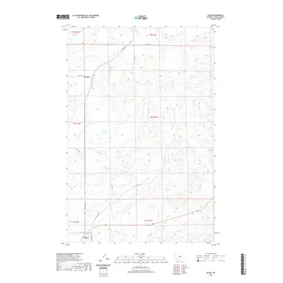
2020 Map of Hilger
USGS Topo · Published 2020About this map
Hilger serves as the primary hub in this Fergus County landscape, situated at the junction of several regional routes that have historically connected the ranching and mining districts of central Montana. The town is the southern terminus for Winifred Rd and is oriented around Main St, while the Maiden Cutoff and N Kendall Rd hint at the area's connections to neighboring mountain ranges and historical mining camps. To the north, the small settlement of Moulton sits along the same highway corridor, surrounded by the headwaters of numerous drainages including Dog Cr and Little Dog Cr. The terrain is defined by a dense network of coulees and creeks such as Deer Cr and Little Deer Cr, illustrating the complex drainage patterns that dictate land use and road placement in this part of the state.
Find a feature on this map
24 named features on this map. Tap any name to fly to it.
Don’t see what you’re looking for? This feature index may not catch every label — zoom into the map to look around manually.
Map Details
Editions of this 2020 Hilger Map
This is the sole edition of this map. No revisions or reprints were ever made.
Other maps of this area

1941 · Lewistown
USGS Topo · 1:62,500

1941 · Judith Peak
USGS Topo · 1:62,500

1944 · Lewistown
USGS Topo · 1:62,500

1944 · Judith Peak
USGS Topo · 1:62,500

1954 · Lewistown
USGS Topo · 1:250,000

1959 · Lewistown
USGS Topo · 1:250,000

1978 · Lewistown
USGS Topo · 1:100,000

1985 · The Horse Ranch
USGS Topo · 1:24,000
1985 · Hilger NW
USGS Topo · 1:24,000
1985 · Kendall
USGS Topo · 1:24,000