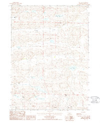
1988 Map of Hill Lake
USGS Topo · Published 1988About this map
Survey Valley defines the core of this Nebraska Sandhills landscape, where isolated ranching outposts are scattered across a complex terrain of dunes and depressions. The 1980s cattle-country economy is evidenced by family operations such as Sweeney Ranch in the northwest and the Curtis Ranch to the east. Water management remains central to life here, with the presence of Cotton Lake, Hill Lake, and numerous isolated Water Wells providing essential resources for livestock in this semi-arid environment. The map details the transition between township lines, specifically T 28 N T 27 N and T 27 N T 26 N, marking the legal boundaries of these vast grazing lands. Other local landmarks include the Henderson Ranch and the neighboring B Wright Ranch and Wright Ranch, illustrating the sparse but established settlement pattern of Cherry County during this era.
Find a feature on this map
11 named features on this map. Tap any name to fly to it.
Don’t see what you’re looking for? This feature index may not catch every label — zoom into the map to look around manually.
Map Details
Editions of this 1988 Hill Lake Map
This is the sole edition of this map. No revisions or reprints were ever made.
Other maps of this area

1948 · Whitman
USGS Topo · 1:62,500

1949 · Steverson Lake
USGS Topo · 1:62,500

1950 · Whitman
USGS Topo · 1:62,500

1950 · Hire
USGS Topo · 1:62,500

1950 · Wolf Lake
USGS Topo · 1:62,500

1951 · Steverson Lake
USGS Topo · 1:62,500

1951 · Wolf Lake
USGS Topo · 1:62,500

1957 · Valentine
USGS Topo · 1:250,000

1959 · Valentine
USGS Topo · 1:250,000

1985 · Mullen
USGS Topo · 1:100,000