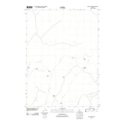
2010 Map of Hill Pasture
USGS Topo · Published 2010About this map
Big Jacks Creek and its many tributaries, including Willies Creek and Cottonwood Creek, define the drainage patterns across this high desert landscape. The presence of remote outposts such as Holman Cabin, Buncel Place, and Harvey Place suggests a history of cattle ranching or seasonal habitation in this corner of Owyhee County. These named dwellings, often situated near water sources or at the base of prominent terrain like Hill Pasture Point and Harvey Point, serve as vital landmarks in an otherwise open range. Transportation is limited to rugged tracks such as Battle Creek Rd and Jacks Creek Rd, which navigate the plateaus and bypass deep incisions like Willies Canyon and Zeno Canyon. This 2010 topographic record provides a snapshot of contemporary land use in a region where geography remains the primary influence on human activity.
Find a feature on this map
16 named features on this map. Tap any name to fly to it.
Don’t see what you’re looking for? This feature index may not catch every label — zoom into the map to look around manually.
Map Details
Editions of this 2010 Hill Pasture Map
This is the sole edition of this map. No revisions or reprints were ever made.
Other maps of this area

1955 · Jordan Valley
USGS Topo · 1:250,000

1955 · Twin Falls
USGS Topo · 1:250,000

1956 · Big Hill
USGS Topo · 1:62,500

1957 · Jordan Valley
USGS Topo · 1:250,000

1958 · Twin Falls
USGS Topo · 1:250,000

1958 · Jordan Valley
USGS Topo · 1:250,000
1972 · Hill Pasture
USGS Topo · 1:24,000

1972 · Wickahoney Point
USGS Topo · 1:24,000

1972 · Turner Table
USGS Topo · 1:24,000
1972 · Big Horse Basin Gap
USGS Topo · 1:24,000