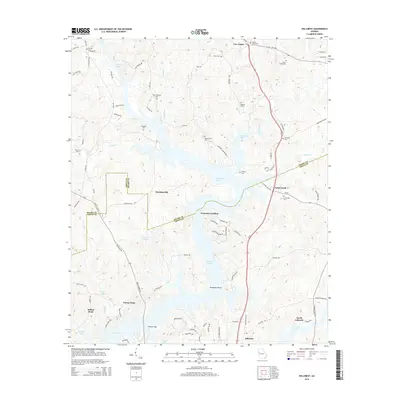
2014 Map of Hillcrest
USGS Topo · Published 2014About this map
West Point Lake dominates this 2014 survey of the border between Heard and Troup Counties, its branching fingers reaching into the surrounding timberlands and valleys. The map documents a landscape defined by the reservoir, where historic landmarks like Swanson Island and Indian Bend are now surrounded by water. Rural communities such as Owensbyville, Buena Vista, and Five Points sit on the high ground, connected by a network of local roads including Owensbyville RD and the major corridor of Us Highway 27. Numerous cemeteries scattered across the terrain, including Old Mt Olive Cem, New Harmony Cem, and Carser Chapel Cem, provide essential data for genealogists tracing local families. Small settlements and landings like Graysons Landing and Point North serve as focal points for the lakefront community during the early twenty-first century.
Find a feature on this map
93 named features on this map. Tap any name to fly to it.
Don’t see what you’re looking for? This feature index may not catch every label — zoom into the map to look around manually.
Map Details
Editions of this 2014 Hillcrest Map
This is the sole edition of this map. No revisions or reprints were ever made.
Other maps of this area

1899 · Wedowee
USGS Topo · 1:125,000

1902 · Wedowee
USGS Topo · 1:125,000

1953 · Atlanta
USGS Topo · 1:250,000

1957 · Atlanta
USGS Topo · 1:250,000

1958 · Atlanta
USGS Topo · 1:250,000

1964 · Hogansville
USGS Topo · 1:24,000
1964 · Mountville
USGS Topo · 1:24,000
1964 · Abbottsford
USGS Topo · 1:24,000
1964 · La Grange
USGS Topo · 1:24,000

1964 · Glenn
USGS Topo · 1:24,000