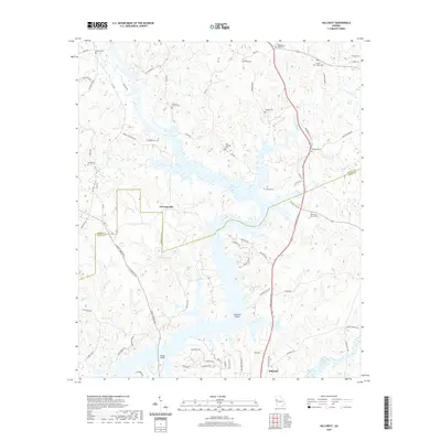
2020 Map of Hillcrest
USGS Topo · Published 2020About this map
West Point Lake dominates the landscape of this Troup County region, its fingers reaching into the surrounding hills along the course of the New River. The map illustrates the contemporary rural settlement patterns of the Georgia-Alabama borderlands, where the boundary between Heard and Troup counties bisects several inlets. For genealogists and local historians, the sheet is exceptionally dense with family-named landmarks and burial grounds, such as Carser Chapel Cem, Old Harmony Cem, and Philpot Cem. The small settlements of Owensbyville and Hillcrest serve as anchors for a network of winding country roads like Philpot Ferry Rd and New Franklin Rd, which trace the higher ground between the lake’s many branches. Significant terrain features like Swanson Island and the confluence of Talley Br provide a detailed look at the modern shoreline and local topography.
Find a feature on this map
77 named features on this map. Tap any name to fly to it.
Don’t see what you’re looking for? This feature index may not catch every label — zoom into the map to look around manually.
Map Details
Editions of this 2020 Hillcrest Map
This is the sole edition of this map. No revisions or reprints were ever made.
Other maps of this area

1899 · Wedowee
USGS Topo · 1:125,000

1902 · Wedowee
USGS Topo · 1:125,000

1953 · Atlanta
USGS Topo · 1:250,000

1957 · Atlanta
USGS Topo · 1:250,000

1958 · Atlanta
USGS Topo · 1:250,000

1964 · Hogansville
USGS Topo · 1:24,000
1964 · Mountville
USGS Topo · 1:24,000
1964 · Abbottsford
USGS Topo · 1:24,000
1964 · La Grange
USGS Topo · 1:24,000

1964 · Glenn
USGS Topo · 1:24,000