
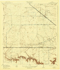
1918 Map of Hillendahl
USGS Topo · Published 1918About this map
Buffalo Bayou carves a deeply etched, winding path across the southern portion of this Harris County landscape, creating a stark contrast to the prairie-like flats to the north. Surveyed just before the late 1910s, the map reveals a rural expanse dominated by early transportation arteries and small community hubs like Hillendahl and Fairbanks. The influence of early rail is evident where the Missouri Kansas and Texas line runs parallel to the Houston and Katy Road, while the Houston and Texas Central railroad cuts diagonally toward the northwest. Local life centers around rural institutions such as the Hillendahl School and Spring Branch School. Numerous small depressions and "pockmarks" across the terrain indicate the natural prairie pothole topography of the Gulf Coastal Plain, a feature largely lost to later suburban development. Waterways like Whiteoak Creek and Brickhouse Gully drain the northern reaches, while Schneiders Lake sits near the bayou bluffs.
Find a feature on this map
22 named features on this map. Tap any name to fly to it.
Don’t see what you’re looking for? This feature index may not catch every label — zoom into the map to look around manually.
Map Details
Editions of this 1918 Hillendahl Map
2 editions found
Other maps of this area

1915 · Bellaire
USGS Topo · 1:24,000

1915 · Houston Heights
USGS Topo · 1:24,000

1915 · Alief
USGS Topo · 1:24,000

1915 · Cypress
USGS Topo · 1:24,000

1915 · Addicks
USGS Topo · 1:24,000

1915 · Hillendahl
USGS Topo · 1:24,000

1915 · Clodine
USGS Topo · 1:24,000

1916 · Aldine
USGS Topo · 1:24,000

1916 · Satsuma
USGS Topo · 1:24,000

1918 · Cypress
USGS Topo · 1:31,680
Featured Places
- Houston, TX
- Jersey Village, TX
- Hunters Creek Village, TX
- Bunker Hill Village, TX
- Spring Valley Village, TX