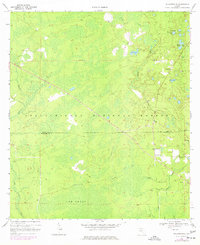
1969 Map of Hilliardville
USGS Topo · Published 1977About this map
Hilliardville and the surrounding reaches of the Apalachicola National Forest define this landscape on the border of Leon and Wakulla Counties. The terrain is dominated by complex water systems, including the expansive Cow Swamp and numerous scattered water bodies such as Dog Pond, Sand Pond, and the Lofton Ponds. Small pockets of settlement and community life are evident at Spring Hill and Helen, with local spiritual and family history anchored at New Light Ch and a nearby Cem.
Find a feature on this map
22 named features on this map. Tap any name to fly to it.
Don’t see what you’re looking for? This feature index may not catch every label — zoom into the map to look around manually.
Map Details
Editions of this 1969 Hilliardville Map
2 editions found
Other maps of this area

1940 · Tallahassee
USGS Topo · 1:62,500

1940 · Arran
USGS Topo · 1:62,500

1942 · Tallahassee
USGS Topo · 1:62,500

1943 · Arran
USGS Topo · 1:62,500

1943 · Tallahassee
USGS Topo · 1:62,500

1943 · Lake Talquin
USGS Topo · 1:62,500

1945 · Bradwell Bay
USGS Topo · 1:31,680

1954 · Tallahassee
USGS Topo · 1:250,000

1959 · Tallahassee
USGS Topo · 1:250,000

1960 · Tallahassee
USGS Topo · 1:250,000