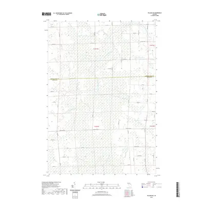
2019 Map of Hillman NE
USGS Topo · Published 2019About this map
The North Branch Thunder Bay River carves through a landscape defined by extensive wetlands and a grid of rural county roads along the border of Presque Isle and Alpena Counties. In this transition between T33N and T32N, the terrain is dominated by the sprawling Long Swamp and numerous small tributaries including Gaffney Cr and Quinn Cr. The human footprint is marked by a traditional surveyor's grid, with names like Reider School Rd and Hagensville Rd hinting at the community structures of earlier generations. Settlement patterns here are sparse, with the map focusing on the intersection of agricultural drainage and timbered lowlands. Major thoroughfares such as Thunder Bay Hwy and Mud Lake Hwy provide the primary east-west transit across this northern Michigan backcountry.
Find a feature on this map
51 named features on this map. Tap any name to fly to it.
Don’t see what you’re looking for? This feature index may not catch every label — zoom into the map to look around manually.
Map Details
Editions of this 2019 Hillman NE Map
This is the sole edition of this map. No revisions or reprints were ever made.
Other maps of this area

1954 · Alpena
USGS Topo · 1:250,000

1955 · Hillman
USGS Topo · 1:62,500

1957 · Alpena
USGS Topo · 1:250,000

1958 · Alpena
USGS Topo · 1:250,000

1969 · Alpena
USGS Topo · 1:250,000

1971 · Hawks
USGS Topo · 1:24,000

1971 · Metz
USGS Topo · 1:24,000

1971 · Polaski
USGS Topo · 1:24,000
1971 · Posen
USGS Topo · 1:24,000

1971 · Lachine
USGS Topo · 1:24,000