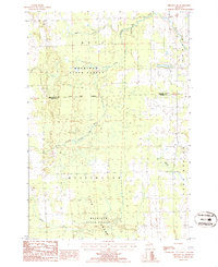
1986 Map of Hillman NE
USGS Topo · Published 1986About this map
Mackinaw State Forest dominates this landscape in northeastern Michigan, where the boundary between Presque Isle and Alpena Counties divides a terrain defined by complex water systems. The North Branch Thunder Bay River meanders through the central sections, fed by tributaries including Quinn Creek and Truax Creek. To the south, the expansive Long Swamp reflects the low-lying, poorly drained nature of the area. This 1980s survey documents the sparsely settled townships of Metz and Wellington, where human activity is primarily limited to resource extraction at a Gravel Pit and the maintenance of fire breaks and trails through the state forest. The grid of section lines and range markers provides a clear framework for locating specific family land holdings within the wilder timberlands of the region.
Find a feature on this map
12 named features on this map. Tap any name to fly to it.
Don’t see what you’re looking for? This feature index may not catch every label — zoom into the map to look around manually.
Map Details
Editions of this 1986 Hillman NE Map
This is the sole edition of this map. No revisions or reprints were ever made.
Other maps of this area

1954 · Alpena
USGS Topo · 1:250,000

1955 · Hillman
USGS Topo · 1:62,500

1957 · Alpena
USGS Topo · 1:250,000

1958 · Alpena
USGS Topo · 1:250,000

1969 · Alpena
USGS Topo · 1:250,000

1971 · Hawks
USGS Topo · 1:24,000

1971 · Metz
USGS Topo · 1:24,000

1971 · Polaski
USGS Topo · 1:24,000
1971 · Posen
USGS Topo · 1:24,000

1971 · Lachine
USGS Topo · 1:24,000