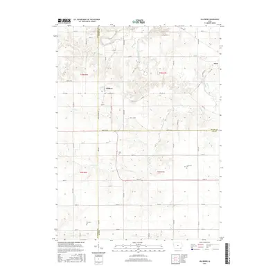
2015 Map of Hillsboro
USGS Topo · Published 2015About this map
Hillsboro and the southwestern outskirts of Salem anchor this landscape along the border of Henry and Van Buren counties. The area is defined by a dendritic network of drainages, including Cedar Creek, Little Cedar Creek, and Rock Cr, which carve through the Iowa prairie. This 2015 survey reveals a persistent rural settlement pattern where agriculture is structured by a rigid grid of roads like Yellow Ave and Henry Lee ST, yet interrupted by the winding paths of Salem RD as it follows the local topography. For those tracing family history in this corner of Iowa, the map serves as a census of local burial grounds. It includes the Hillsboro Cem, Bayles Cem, Cottonwood Cem, and Wallingford Cem, each situated near long-established section lines and creek bends that have defined property boundaries for generations.
Find a feature on this map
53 named features on this map. Tap any name to fly to it.
Don’t see what you’re looking for? This feature index may not catch every label — zoom into the map to look around manually.
Map Details
Editions of this 2015 Hillsboro Map
This is the sole edition of this map. No revisions or reprints were ever made.
Other maps of this area

1958 · Burlington
USGS Topo · 1:250,000

1961 · Burlington
USGS Topo · 1:250,000

1963 · Burlington
USGS Topo · 1:250,000

1968 · Bonaparte
USGS Topo · 1:24,000

1968 · Donnellson
USGS Topo · 1:24,000

1968 · Farmington
USGS Topo · 1:24,000

1980 · Lockridge West
USGS Topo · 1:24,000

1980 · Lockridge East
USGS Topo · 1:24,000

1981 · Mount Pleasant
USGS Topo · 1:24,000
1981 · Salem
USGS Topo · 1:24,000