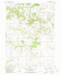
1981 Map of Hillsboro
USGS Topo · Published 1981About this map
Hillsboro occupies the high ground above the drainage basins of Cedar Creek and Little Cedar Creek in this 1981 snapshot of southeast Iowa. The map documents a landscape defined by sharp topographical contrasts, where flat upland farmsteads drop suddenly into the timbered ravines carved by Mud Creek and Rock Creek. The infrastructure of a bygone era is clearly visible through the Old Railroad Grade that once connected these rural communities.
Find a feature on this map
21 named features on this map. Tap any name to fly to it.
Don’t see what you’re looking for? This feature index may not catch every label — zoom into the map to look around manually.
Map Details
Editions of this 1981 Hillsboro Map
This is the sole edition of this map. No revisions or reprints were ever made.
Other maps of this area

1958 · Burlington
USGS Topo · 1:250,000

1961 · Burlington
USGS Topo · 1:250,000

1963 · Burlington
USGS Topo · 1:250,000

1968 · Bonaparte
USGS Topo · 1:24,000

1968 · Donnellson
USGS Topo · 1:24,000

1968 · Farmington
USGS Topo · 1:24,000

1980 · Lockridge West
USGS Topo · 1:24,000

1980 · Lockridge East
USGS Topo · 1:24,000

1981 · Mount Pleasant
USGS Topo · 1:24,000
1981 · Salem
USGS Topo · 1:24,000