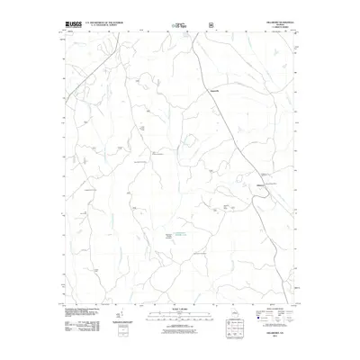
2011 Map of Hillsboro
USGS Topo · Published 2011About this map
The settlement of Hillsboro and the nearby village of Adgateville anchor this portion of Jasper County, characterized by a network of rural roads and scattered hunting camps. Genealogists will find significant local history at the Hillsboro Cemetery, John Tillman Cemetery, and John Gordon Cemetery, which are tucked away among the many branches and creeks that define the drainage of the area. The landscape is dominated by a complex system of waterways, including Falling Creek and the central Stalking Head Creek, which feed into the Piedmont Wildlife Lake. The importance of the outdoor economy is evident through the naming of several specific sites such as Camp Six Hunt Camp, Lungsford Hunt Camp, and Tribble Fields. Significant infrastructure includes the Hillsboro Post Office and the Piedmont Wildlife Lake Dam, providing a clear record of local geography as it stood in the early 2010s.
Find a feature on this map
37 named features on this map. Tap any name to fly to it.
Don’t see what you’re looking for? This feature index may not catch every label — zoom into the map to look around manually.
Map Details
Editions of this 2011 Hillsboro Map
This is the sole edition of this map. No revisions or reprints were ever made.
Other maps of this area

1951 · Forsyth
USGS Topo · 1:62,500

1953 · Athens
USGS Topo · 1:250,000

1958 · Athens
USGS Topo · 1:250,000

1959 · Athens
USGS Topo · 1:250,000

1963 · Athens
USGS Topo · 1:250,000

1964 · Lloyd Shoals Dam
USGS Topo · 1:24,000

1964 · Gray
USGS Topo · 1:24,000
1964 · Dames Ferry
USGS Topo · 1:24,000

1964 · Stanfordville
USGS Topo · 1:24,000

1964 · Hillsboro
USGS Topo · 1:24,000