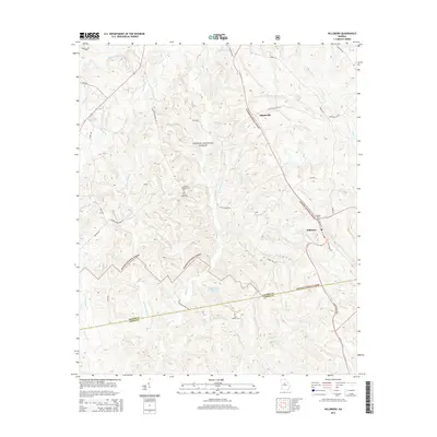
2014 Map of Hillsboro
USGS Topo · Published 2014About this map
Oconee National Forest dominates this Piedmont landscape, preserving a network of creeks and timberlands where family histories are etched into the terrain. Small rural settlements like Hillsboro and Adgateville serve as anchors along the roadway network, particularly where State Rte 11 and the Old Macon Rd traverse the hills. The map is a vital resource for genealogists, documenting secluded burial sites such as the John H Tillman Cem, Hillsboro Cem, and the John Gordon Cem near the Jasper Co and Jones Co border. Waterways including Falling Creek and Stalking Head Cr define the drainage patterns that shaped early land lots. The presence of Piedmont Wildlife Lake and numerous forest service roads suggests a landscape managed for both timber and conservation, while retaining the names of legacy families through features like Towns Br and Ezell Rd.
Find a feature on this map
39 named features on this map. Tap any name to fly to it.
Don’t see what you’re looking for? This feature index may not catch every label — zoom into the map to look around manually.
Map Details
Editions of this 2014 Hillsboro Map
This is the sole edition of this map. No revisions or reprints were ever made.
Other maps of this area

1951 · Forsyth
USGS Topo · 1:62,500

1953 · Athens
USGS Topo · 1:250,000

1958 · Athens
USGS Topo · 1:250,000

1959 · Athens
USGS Topo · 1:250,000

1963 · Athens
USGS Topo · 1:250,000

1964 · Lloyd Shoals Dam
USGS Topo · 1:24,000

1964 · Gray
USGS Topo · 1:24,000
1964 · Dames Ferry
USGS Topo · 1:24,000

1964 · Stanfordville
USGS Topo · 1:24,000

1964 · Hillsboro
USGS Topo · 1:24,000