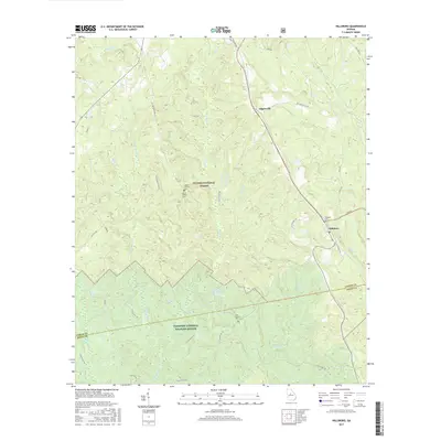
2017 Map of Hillsboro
USGS Topo · Published 2017About this map
Hillsboro and Adgateville anchor this portion of the Georgia Piedmont, situated at the boundary of Jasper Co and Jones Co. Much of the terrain is defined by the massive conservation lands of the Oconee National Forest and the Piedmont National Wildlife Refuge, where complex drainage systems like Falling Creek and Stalking Head Creek carve through the wooded landscape. For genealogists, the map preserves the locations of family landmarks such as the John H Tillman Cemetery and the John Gordon Cemetery. The map also details local transit corridors like Old Macon Road and Old Agateville Road, alongside newer additions like the Fried Green 50, illustrating how modern infrastructure and recreational routes overlay the traditional rural settlement patterns and historic cemeteries of middle Georgia.
Find a feature on this map
38 named features on this map. Tap any name to fly to it.
Don’t see what you’re looking for? This feature index may not catch every label — zoom into the map to look around manually.
Map Details
Editions of this 2017 Hillsboro Map
This is the sole edition of this map. No revisions or reprints were ever made.
Other maps of this area

1951 · Forsyth
USGS Topo · 1:62,500

1953 · Athens
USGS Topo · 1:250,000

1958 · Athens
USGS Topo · 1:250,000

1959 · Athens
USGS Topo · 1:250,000

1963 · Athens
USGS Topo · 1:250,000

1964 · Lloyd Shoals Dam
USGS Topo · 1:24,000

1964 · Gray
USGS Topo · 1:24,000
1964 · Dames Ferry
USGS Topo · 1:24,000

1964 · Stanfordville
USGS Topo · 1:24,000

1964 · Hillsboro
USGS Topo · 1:24,000