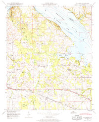
1948 Map of Hillsboro
USGS Topo · Published 1969About this map
Hillsboro serves as the focal point of this Lawrence County landscape during the late 1940s, situated along the Southern railroad line and the Joe Wheeler Highway. The map reveals a deeply established rural community defined by a high density of family and community cemeteries, such as Hillsboro Cem, Brides Hill Cem, and Pointer Cem. To the north, the Tennessee River expands into Wheeler Lake, a transformation that reshaped the local geography along Milton Bluff and Peters Ridge. Educational and spiritual life is well-documented through numerous landmarks including Canaan Sch, David Temple School, and Bethel Ch. This survey provides a precise view of the region's mid-century transition, showing the intersection of traditional agricultural settlements like Pointer Quarters with the burgeoning recreational and industrial potential of the Tennessee Valley Authority's water management projects.
Find a feature on this map
47 named features on this map. Tap any name to fly to it.
Don’t see what you’re looking for? This feature index may not catch every label — zoom into the map to look around manually.
Map Details
Editions of this 1948 Hillsboro Map
This is the sole edition of this map. No revisions or reprints were ever made.
Other maps of this area

1914 · Rogersville
USGS Topo · 1:48,000

1916 · Rogersville
USGS Topo · 1:62,500

1936 · Caddo
USGS Topo · 1:24,000

1936 · Thorntontown
USGS Topo · 1:24,000

1936 · Stewart Cross Roads
USGS Topo · 1:24,000

1936 · Courtland
USGS Topo · 1:24,000

1936 · Ripley
USGS Topo · 1:24,000

1936 · Trinity
USGS Topo · 1:24,000

1936 · Hillsboro
USGS Topo · 1:24,000

1936 · Cairo
USGS Topo · 1:24,000