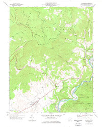
1977 Map of Hillsboro
USGS Topo · Published 1978About this map
Pearl S Buck Birthplace anchors the cultural geography of this Pocahontas County landscape, situated on the western edge of the plateau known as Little Levels. The settlement of Hillsboro serves as the local hub, connected by roads that wind through the valley floor toward Mill Point and the banks of the Greenbrier River. The river corridor is a primary conduit for transport and commerce, followed closely by the Chesapeake and Ohio railroad line as it passes through Seebert and Huntersville.
Find a feature on this map
57 named features on this map. Tap any name to fly to it.
Don’t see what you’re looking for? This feature index may not catch every label — zoom into the map to look around manually.
Map Details
Editions of this 1977 Hillsboro Map
2 editions found
Other maps of this area

1891 · Huntersville
USGS Topo · 1:125,000

1894 · Huntersville
USGS Topo · 1:125,000

1915 · Webster Springs
USGS Topo · 1:48,000

1918 · Webster Springs
USGS Topo · 1:62,500

1923 · Lobelia
USGS Topo · 1:48,000

1923 · Marlinton
USGS Topo · 1:48,000

1923 · Mingo
USGS Topo · 1:48,000

1925 · Mingo
USGS Topo · 1:62,500

1925 · Marlinton
USGS Topo · 1:62,500

1925 · Lobelia
USGS Topo · 1:62,500