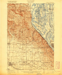
1918 Map of Hillsboro
USGS Topo · Published 1920About this map
Hillsboro serves as the focal point of a landscape where the agricultural Tualatin Valley meets the industrial and maritime corridors of the Columbia River and Willamette River. The area is densely patterned with early twentieth-century infrastructure, featuring the routes of the Oregon Electric Railway, United Railways, and the Spokane Portland and Seattle Ry. These rail lines connect scattered rural communities such as Orenco, Witch Hazel, and Glencoe to the riverside industry at Linnton and St Johns.
Find a feature on this map
100 named features on this map. Tap any name to fly to it.
Don’t see what you’re looking for? This feature index may not catch every label — zoom into the map to look around manually.
Map Details
Editions of this 1918 Hillsboro Map
4 editions found
Other maps of this area

1897 · Portland
USGS Topo · 1:62,500

1905 · Portland
USGS Topo · 1:62,500

1914 · Oregon City
USGS Topo · 1:62,500

1915 · Hillsboro
USGS Topo · 1:62,500

1916 · Tualatin
USGS Topo · 1:62,500

1918 · Hillsboro
USGS Topo · 1:62,500

1922 · St. Helens
USGS Topo · 1:62,500

1939 · Oregon City
USGS Topo · 1:62,500

1939 · Tualatin
USGS Topo · 1:62,500

1940 · Tualatin
USGS Topo · 1:62,500