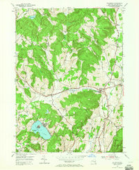
1953 Map of Hillsdale
USGS Topo · Published 1965About this map
The New York Central railroad corridor anchors the landscape of eastern Columbia County in the early 1950s, connecting the village of Hillsdale with the smaller rail stops at Craryville and North Hillsdale. This era shows a community defined by its water resources and varied topography, where Agawamuck Creek feeds the Philmont Res and the Roeliff Jansen Kill winds through the eastern valleys. The map provides significant genealogical value, documenting family-named landmarks and historical burial sites like Collins Cem, Niver Cem, and Williams Cem. Educational and social hubs of the period are clearly marked, notably the Roeliff Jansen Sch and the Crum Church. The southern portion of the quadrangle is dominated by the waters of Copake Lake, featuring Mosquito Island, and the protected lands of Taconic State Park near the state border.
Find a feature on this map
37 named features on this map. Tap any name to fly to it.
Don’t see what you’re looking for? This feature index may not catch every label — zoom into the map to look around manually.
Map Details
Editions of this 1953 Hillsdale Map
Other maps of this area

1885 · Sheffield
USGS Topo · 1:62,500

1888 · Sheffield
USGS Topo · 1:62,500

1888 · Pittsfield
USGS Topo · 1:62,500

1890 · Pittsfield
USGS Topo · 1:62,500

1891 · Sheffield
USGS Topo · 1:62,500

1893 · Sheffield
USGS Topo · 1:62,500

1893 · Pittsfield
USGS Topo · 1:62,500

1894 · Pittsfield
USGS Topo · 1:62,500

1897 · Pittsfield
USGS Topo · 1:62,500

1897 · Sheffield
USGS Topo · 1:62,500