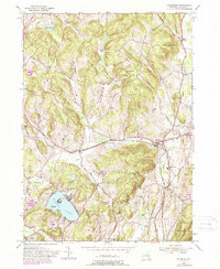
1953 Map of Hillsdale
USGS Topo · Published 1988About this map
Hillsdale and its surrounding hamlets are depicted here at the start of the 1950s, with later updates showing the post-war development of the Taconic State Parkway. The New York Central railroad corridor remains a primary axis for the region, passing through Craryville and Hillsdale south of the prominent heights of Lyon Mountain. Local heritage is well-preserved through numerous small burial grounds such as Niver Cem, Coffins Cem, and Williams Cem, along with the Drum Church in the northwest. The landscape is defined by its significant water bodies and valleys, from the recreationally active Copake Lake and its Mosquito Island to the winding course of the Roeliff Jansen Kill. The map provides a detailed view of the transition between agrarian valley life and the protected wilderness of Taconic State Park.
Find a feature on this map
41 named features on this map. Tap any name to fly to it.
Don’t see what you’re looking for? This feature index may not catch every label — zoom into the map to look around manually.
Map Details
Editions of this 1953 Hillsdale Map
Other maps of this area

1885 · Sheffield
USGS Topo · 1:62,500

1888 · Sheffield
USGS Topo · 1:62,500

1888 · Pittsfield
USGS Topo · 1:62,500

1890 · Pittsfield
USGS Topo · 1:62,500

1891 · Sheffield
USGS Topo · 1:62,500

1893 · Sheffield
USGS Topo · 1:62,500

1893 · Pittsfield
USGS Topo · 1:62,500

1894 · Pittsfield
USGS Topo · 1:62,500

1897 · Pittsfield
USGS Topo · 1:62,500

1897 · Sheffield
USGS Topo · 1:62,500