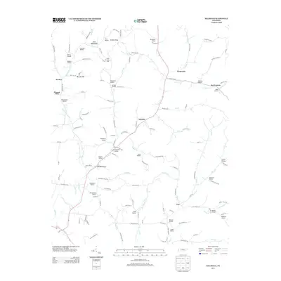
2013 Map of Hillsdale
USGS Topo · Published 2013About this map
Hillsdale sits at the heart of this North Tennessee landscape, where the winding waters of Goose Cr and the Middle Fork Goose Cr carve through a terrain defined by named hollows and ridges. The settlement pattern follows these narrow valleys, with Beech Grove and Meadorville serving as local anchors along the primary road corridors. The map reveals a deeply localized geography, where family-named landmarks like McClanahan Hollow, Wright Hollow, and Woodmore Hollow suggest generations of land use and genealogy. High points such as Hard Scratch Hill and Peddlers Ridge overlook a complex network of smaller tributaries, including Pumpkin Br and Honey Prong. This 2013 survey illustrates the enduring rural character of the region, where communities like New Harmony, Cato, and Beech Bottom remain connected by historical routes that navigate the intricate drainage systems of the Cumberland River watershed.
Find a feature on this map
137 named features on this map. Tap any name to fly to it.
Don’t see what you’re looking for? This feature index may not catch every label — zoom into the map to look around manually.
Map Details
Editions of this 2013 Hillsdale Map
This is the sole edition of this map. No revisions or reprints were ever made.
Other maps of this area

1931 · Lafayette
USGS Topo · 1:62,500

1931 · Red Boiling Springs
USGS Topo · 1:62,500

1932 · Carthage
USGS Topo · 1:62,500

1956 · Corbin
USGS Topo · 1:250,000

1956 · Nashville
USGS Topo · 1:250,000

1958 · Corbin
USGS Topo · 1:250,000

1958 · Westmoreland
USGS Topo · 1:24,000

1958 · Bellwood
USGS Topo · 1:24,000

1958 · Dixon Springs
USGS Topo · 1:24,000
1958 · Lafayette
USGS Topo · 1:24,000