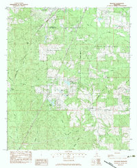
1983 Map of Hillsdale
USGS Topo · Published 1983About this map
The boundary between Lamar and Pearl River counties divides this Mississippi landscape, dominated by the timbered stretches of the De Soto National Forest. Settlement is concentrated around Hillsdale and the southern edge of Lumberton, with the Southern railroad line cutting through the western terrain near Red Top. The local economy of the early 1980s is defined by a mix of industry and agriculture, featuring the active Pistol Ridge Oil and Gas Field in the northeast and the Wolf River Ranch Airstrip near Hillsdale Lake.
Find a feature on this map
43 named features on this map. Tap any name to fly to it.
Don’t see what you’re looking for? This feature index may not catch every label — zoom into the map to look around manually.
Map Details
Editions of this 1983 Hillsdale Map
This is the sole edition of this map. No revisions or reprints were ever made.
Other maps of this area

1953 · Hattiesburg
USGS Topo · 1:250,000

1953 · Mobile
USGS Topo · 1:250,000

1957 · Mobile
USGS Topo · 1:250,000

1958 · Hattiesburg
USGS Topo · 1:250,000

1958 · Carnes
USGS Topo · 1:62,500

1959 · Poplarville
USGS Topo · 1:62,500

1960 · Mobile
USGS Topo · 1:250,000

1963 · Mobile
USGS Topo · 1:250,000

1963 · Rock Hill
USGS Topo · 1:24,000

1964 · Lumberton
USGS Topo · 1:24,000