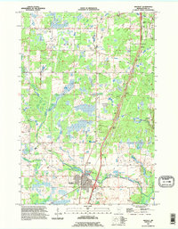
1991 Map of Hinckley
USGS Topo · Published 1995About this map
The Grindstone River and its various tributaries define this Pine County landscape during the early 1990s. The regional rail economy is anchored by the Burlington Northern line, which connects the primary settlements of Hinckley and Sandstone. This survey shows a specialized local infrastructure, featuring the State Fish Hatchery and several aviation sites like the Municipal Airport and Workman Landing Strip.
Find a feature on this map
26 named features on this map. Tap any name to fly to it.
Don’t see what you’re looking for? This feature index may not catch every label — zoom into the map to look around manually.
Map Details
Editions of this 1991 Hinckley Map
This is the sole edition of this map. No revisions or reprints were ever made.
Other maps of this area

1953 · Duluth
USGS Topo · 1:250,000

1953 · Stillwater
USGS Topo · 1:250,000

1955 · Stillwater
USGS Topo · 1:250,000

1958 · Stillwater
USGS Topo · 1:250,000

1958 · Duluth
USGS Topo · 1:250,000

1961 · Sandstone
USGS Topo · 1:62,500

1961 · Brook Park
USGS Topo · 1:62,500

1961 · Pine City
USGS Topo · 1:62,500

1965 · Stillwater
USGS Topo · 1:250,000

1968 · Giese
USGS Topo · 1:24,000