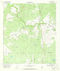
1969 Map of Hindes
USGS Topo · Published 1971About this map
The low-lying plains of South Texas, where the corners of Frio, Atascosa, La Salle, and McMullen Counties converge, are defined by an intricate drainage system feeding into San Miguel Creek. This late 1960s landscape shows the transition from ranching to petroleum extraction, evidenced by various Oil Wells and Drill Holes scattered across the terrain. The small community of Hindes sits along an Old Railroad Grade, illustrating how former transit corridors shaped local settlement patterns. Several intermittent watercourses, including Mustang Creek and Raccoon Creek, carve through the scrubland toward the main valley. Genealogists and local historians will find the named R L Ranch and the settlement at Orelia useful for identifying family lands and rural hubs as they existed during this era of Texas ranching history.
Find a feature on this map
20 named features on this map. Tap any name to fly to it.
Don’t see what you’re looking for? This feature index may not catch every label — zoom into the map to look around manually.
Map Details
Editions of this 1969 Hindes Map
This is the sole edition of this map. No revisions or reprints were ever made.
Other maps of this area

1934 · Schattel
USGS Topo · 1:62,500

1953 · Crystal City
USGS Topo · 1:250,000

1955 · Crystal City
USGS Topo · 1:250,000

1956 · Jourdanton
USGS Topo · 1:62,500

1956 · Hindes
USGS Topo · 1:62,500

1956 · Franklin Settlement
USGS Topo · 1:62,500

1961 · Crystal City
USGS Topo · 1:250,000

1968 · Crystal City
USGS Topo · 1:250,000
1968 · Charlotte
USGS Topo · 1:24,000
1968 · Keystone Ranch
USGS Topo · 1:24,000