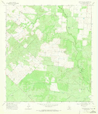
1968 Map of Keystone Ranch
USGS Topo · Published 1971About this map
Keystone Ranch serves as the central hub of this South Texas landscape, situated amongst the scrub and undulating terrain of Frio County. The map reveals an environment defined by water management in a semi-arid region, evidenced by numerous named wells and windmills such as Creek Windmill, Loston Windmill, and Triangle Windmill. These features indicate the vital importance of groundwater for cattle ranching and local operations during the late 1960s.
Find a feature on this map
18 named features on this map. Tap any name to fly to it.
Don’t see what you’re looking for? This feature index may not catch every label — zoom into the map to look around manually.
Map Details
Editions of this 1968 Keystone Ranch Map
2 editions found
Other maps of this area

1927 · Pearsall
USGS Topo · 1:62,500

1934 · Schattel
USGS Topo · 1:62,500

1942 · Dilley
USGS Topo · 1:62,500

1953 · Crystal City
USGS Topo · 1:250,000

1955 · Crystal City
USGS Topo · 1:250,000

1956 · Hindes
USGS Topo · 1:62,500

1961 · Crystal City
USGS Topo · 1:250,000

1964 · Pearsall South
USGS Topo · 1:24,000
1964 · Pearsall North
USGS Topo · 1:24,000

1968 · Crystal City
USGS Topo · 1:250,000