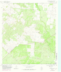
1968 Map of Keystone Ranch
USGS Topo · Published 1982About this map
Keystone Ranch serves as the central landmark for this section of South Texas, where a network of water resources and ranching infrastructure defines the arid landscape. The area is heavily marked by scattered water management features, including several family-named or descriptive landmarks like Loston Windmill, Greek Windmill, and Brushy Windmill. These structures, alongside Howard Lake, represent the critical importance of water for livestock in the Brush Country.
Find a feature on this map
19 named features on this map. Tap any name to fly to it.
Don’t see what you’re looking for? This feature index may not catch every label — zoom into the map to look around manually.
Map Details
Editions of this 1968 Keystone Ranch Map
2 editions found
Other maps of this area

1927 · Pearsall
USGS Topo · 1:62,500

1934 · Schattel
USGS Topo · 1:62,500

1942 · Dilley
USGS Topo · 1:62,500

1953 · Crystal City
USGS Topo · 1:250,000

1955 · Crystal City
USGS Topo · 1:250,000

1956 · Hindes
USGS Topo · 1:62,500

1961 · Crystal City
USGS Topo · 1:250,000

1964 · Pearsall South
USGS Topo · 1:24,000
1964 · Pearsall North
USGS Topo · 1:24,000

1968 · Crystal City
USGS Topo · 1:250,000