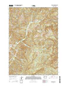
2014 Map of Hinkle Creek
USGS Topo · Published 2014About this map
Hawthorne and the surrounding timberlands of Douglas County are defined by an intricate network of drainage systems and high ridges in this 2014 survey. The landscape is dominated by the steep divides of Timothy Ridge and Taylor Ridge, which separate the various forks and tributaries of Calapooya Creek and Hinkle Creek. Transportation through these narrow valleys relies on routes like Nonpareil Rd, connecting isolated pockets of activity with the broader region. Local landmarks such as The Buttes, Gobblers Knob, and Yellow Butte provide distinct navigational points above the creek bottoms. Geographers and local historians can trace the specific water sources that have sustained this area for generations, including Bear Wallow Spring and the numerous family-named creeks like Gilbreath Cr and Haney Cr that feed the larger river systems.
Find a feature on this map
44 named features on this map. Tap any name to fly to it.
Don’t see what you’re looking for? This feature index may not catch every label — zoom into the map to look around manually.
Map Details
Editions of this 2014 Hinkle Creek Map
This is the sole edition of this map. No revisions or reprints were ever made.
Other maps of this area

1897 · Roseburg
USGS Topo · 1:125,000

1900 · Roseburg
USGS Topo · 1:125,000

1935 · Lowell
USGS Topo · 1:96,000

1942 · Lowell
USGS Topo · 1:125,000

1954 · Anlauf
USGS Topo · 1:62,500

1954 · Glide
USGS Topo · 1:62,500

1955 · Mace Mtn
USGS Topo · 1:62,500

1955 · Culp Creek
USGS Topo · 1:62,500

1958 · Roseburg
USGS Topo · 1:250,000

1959 · Roseburg
USGS Topo · 1:250,000