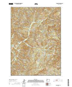
2020 Map of Hinkle Creek
USGS Topo · Published 2020About this map
Hawthorne and the surrounding timberlands of Douglas County are defined by a complex network of ridges and drainage basins as they appeared in 2020. The landscape is carved by Hinkle Cr and Calapooia Cr, with numerous seasonal and spring-fed tributaries such as Gossett Cr and White Cr branching into the steep terrain. Dominant landmarks like Haney Ridge, Taylor Ridge, and the distinct Yellow Butte provide significant topographical relief. A intricate system of Bureau of Land Management routes, including BLM RD 24 3 31 and BLM RD 25 4 19 0, suggests the ongoing importance of forest management and access in this region. This modern survey captures the persistence of remote place names like Buzzard Roost and Gobblers Knob within the deep interior of the Oregon Coast Range.
Find a feature on this map
64 named features on this map. Tap any name to fly to it.
Don’t see what you’re looking for? This feature index may not catch every label — zoom into the map to look around manually.
Map Details
Editions of this 2020 Hinkle Creek Map
This is the sole edition of this map. No revisions or reprints were ever made.
Other maps of this area

1897 · Roseburg
USGS Topo · 1:125,000

1900 · Roseburg
USGS Topo · 1:125,000

1935 · Lowell
USGS Topo · 1:96,000

1942 · Lowell
USGS Topo · 1:125,000

1954 · Anlauf
USGS Topo · 1:62,500

1954 · Glide
USGS Topo · 1:62,500

1955 · Mace Mtn
USGS Topo · 1:62,500

1955 · Culp Creek
USGS Topo · 1:62,500

1958 · Roseburg
USGS Topo · 1:250,000

1959 · Roseburg
USGS Topo · 1:250,000