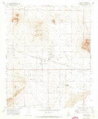
1971 Map of Hinkley
USGS Topo · Published 1973About this map
Hinkley serves as the focal point of this Mojave Desert landscape, centered at the intersection of agricultural grid-lines and the Atchison Topeka and Santa Fe railroad. The settlement pattern reveals a community organized around the Hinkley Union Sch and local gathering spots like the Grange Hall. To the south, the Mojave River carves a path through the valley, flanked by the residential development at Highcrest.
Find a feature on this map
34 named features on this map. Tap any name to fly to it.
Don’t see what you’re looking for? This feature index may not catch every label — zoom into the map to look around manually.
Map Details
Editions of this 1971 Hinkley Map
3 editions found
Other maps of this area

1915 · Searles Lake
USGS Topo · 1:250,000

1932 · Barstow
USGS Topo · 1:125,000

1934 · Barstow
USGS Topo · 1:125,000

1947 · Trona
USGS Topo · 1:250,000

1948 · Trona
USGS Topo · 1:250,000

1953 · San Bernardino
USGS Topo · 1:250,000

1953 · Trona
USGS Topo · 1:250,000

1955 · Opal Mountain
USGS Topo · 1:62,500

1956 · San Bernardino
USGS Topo · 1:250,000

1956 · Fremont Peak
USGS Topo · 1:62,500