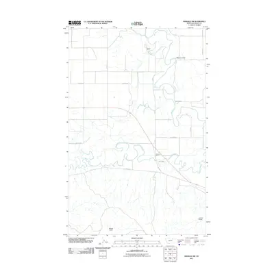
2011 Map of Hinsdale NW
USGS Topo · Published 2011About this map
The meandering course of the Milk River dominates this north-central Montana landscape, where it flows through a corridor defined by established livestock operations and river crossings. Ranching history is deeply embedded here, with several family-named properties such as Tanner's Ranch, Drabb's Ranch, and Hammond's Ranch positioned near the water and primary transit routes. Further south, the map traces the intricate bends of Beaver Creek and the drainage patterns of McNab Coulee and Limekiln Coulee. Transportation in the region relies on a network of rural roads, including Old Hwy 21 and Reynolds Rd, which provide access to the river's edge at Miles Crossing. The layout reflects a traditional high-plains agriculture and ranching economy where settlement is focused on water access and grazing land.
Find a feature on this map
22 named features on this map. Tap any name to fly to it.
Don’t see what you’re looking for? This feature index may not catch every label — zoom into the map to look around manually.
Map Details
Editions of this 2011 Hinsdale NW Map
This is the sole edition of this map. No revisions or reprints were ever made.
Other maps of this area

1905 · Saco Special
USGS Topo · 1:62,500

1906 · Hinsdale Special Map
USGS Topo · 1:62,500

1954 · Glasgow
USGS Topo · 1:250,000

1957 · Glasgow
USGS Topo · 1:250,000

1958 · Glasgow
USGS Topo · 1:250,000

1984 · Bjornberg Bridge
USGS Topo · 1:24,000

1984 · Double S Hill
USGS Topo · 1:24,000
1984 · Jones Coulee
USGS Topo · 1:24,000

1984 · Ashford Coulee
USGS Topo · 1:24,000
1984 · Saco
USGS Topo · 1:24,000