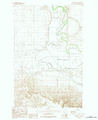
1984 Map of Hinsdale NW
USGS Topo · Published 1984About this map
The Milk River meanders sharply through this Valley County landscape, creating a complex network of oxbows and flood-control infrastructure. This 1984 provisional survey highlights the vital water management systems used in this part of Montana, specifically the South Nelson Canal and the protective Nelson Levee. The confluence of diverse water sources is evident as Beaver Creek winds through the southern portion of the quadrangle, flanked by distinctive landforms such as Martin Coulee and McNab Coulee. The map illustrates how human engineering, such as various irrigation ditches, has been laid over the natural drainage patterns of the Missouri River basin to support the agricultural needs of the region during the late 1970s and early 1980s.
Find a feature on this map
8 named features on this map. Tap any name to fly to it.
Don’t see what you’re looking for? This feature index may not catch every label — zoom into the map to look around manually.
Map Details
Editions of this 1984 Hinsdale NW Map
This is the sole edition of this map. No revisions or reprints were ever made.
Other maps of this area

1905 · Saco Special
USGS Topo · 1:62,500

1906 · Hinsdale Special Map
USGS Topo · 1:62,500

1954 · Glasgow
USGS Topo · 1:250,000

1957 · Glasgow
USGS Topo · 1:250,000

1958 · Glasgow
USGS Topo · 1:250,000

1984 · Bjornberg Bridge
USGS Topo · 1:24,000

1984 · Double S Hill
USGS Topo · 1:24,000
1984 · Jones Coulee
USGS Topo · 1:24,000

1984 · Ashford Coulee
USGS Topo · 1:24,000
1984 · Saco
USGS Topo · 1:24,000