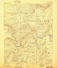
1892 Map of Hinton
USGS Topo · Published 1899About this map
The New River and Greenbrier River converge at Hinton in this late nineteenth-century survey, revealing a landscape defined by rugged topography and nascent industrial transit. The arrival of the Chesapeake and Ohio Railroad transformed the region, evidenced here by significant engineering feats like the Big Bend Tunnel near Talcott and several other tunnels including Mann Tunnel and Fort Spring Tunnel. These rail corridors follow the winding riverbanks, connecting remote settlements such as Alderson, Lowell, and the Greenbrier Stock Yards.
Find a feature on this map
128 named features on this map. Tap any name to fly to it.
Don’t see what you’re looking for? This feature index may not catch every label — zoom into the map to look around manually.
Map Details
Editions of this 1892 Hinton Map
5 editions found

Other maps of this area

1887 · Pocahontas
USGS Topo · 1:125,000

1887 · Hinton
USGS Topo · 1:125,000

1887 · Lewisburg
USGS Topo · 1:125,000

1889 · Nicholas
USGS Topo · 1:125,000

1890 · Dublin
USGS Topo · 1:125,000

1890 · Christiansburg
USGS Topo · 1:125,000

1891 · Lewisburg
USGS Topo · 1:125,000

1891 · Nicholas
USGS Topo · 1:125,000

1891 · Huntersville
USGS Topo · 1:125,000

1891 · Pocahontas
USGS Topo · 1:125,000