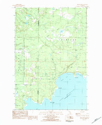
1983 Map of Hiram Point
USGS Topo · Published 1984About this map
The rugged shoreline of Lake Michigan in Schoolcraft County takes center stage in this early 1980s provisional study. The landscape is defined by the extensive Lake Superior State Forest, where a network of woods roads and trails like Garden Grade Road and Goldmine Road penetrate the dense timberland and wetlands. The map details the transition from the high interior woods down to the coastal features of Parent Bay and the sheltered waters of Little Harbor.
Find a feature on this map
27 named features on this map. Tap any name to fly to it.
Don’t see what you’re looking for? This feature index may not catch every label — zoom into the map to look around manually.
Map Details
Editions of this 1983 Hiram Point Map
2 editions found
Other maps of this area

1931 · Cooks NE
USGS Topo · 1:31,680

1931 · Cooks NW
USGS Topo · 1:31,680

1932 · Burnt Bluff NE
USGS Topo · 1:31,680

1932 · Garden SE
USGS Topo · 1:31,680

1932 · Garden NE
USGS Topo · 1:31,680

1954 · Escanaba
USGS Topo · 1:250,000

1957 · Escanaba
USGS Topo · 1:250,000

1958 · Escanaba
USGS Topo · 1:250,000

1958 · Cooks
USGS Topo · 1:62,500

1958 · Garden
USGS Topo · 1:62,500