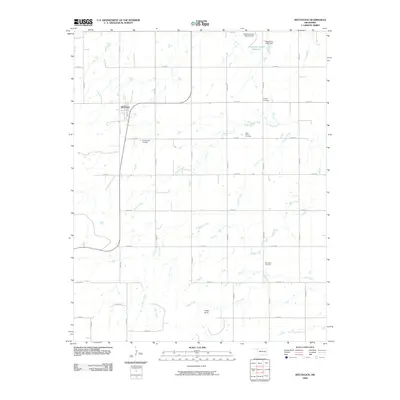
2009 Map of Hitchcock
USGS Topo · Published 2009About this map
Hitchcock serves as the primary settlement hub in this part of Blaine County, situated within a landscape defined by an extensive grid of section-line roads and winding creek beds. This 2009 survey highlights the agricultural and rural character of the region, where the hydrology of Willow Creek, Cooper Creek, and Otter Creek shapes the local topography. A notable concentration of community burial grounds, including Winnview Cemetery, Saint John's Cemetery, Cottonwood Cemetery, and Cooper Cemetery, reflects the long-standing family and township history of the area. Water management infrastructure is evident near the northern border, marked by the Oknoname 01101 Reservoir and its associated dam. The presence of Cedar Knoll provides a subtle topographic variation in the southern half of the quadrangle, which is otherwise dominated by the steady convergence of small tributaries like Cedar Creek.
Find a feature on this map
32 named features on this map. Tap any name to fly to it.
Don’t see what you’re looking for? This feature index may not catch every label — zoom into the map to look around manually.
Map Details
Editions of this 2009 Hitchcock Map
This is the sole edition of this map. No revisions or reprints were ever made.
Other maps of this area

1893 · Loyal
USGS Topo · 1:62,500

1893 · Ames
USGS Topo · 1:62,500

1955 · Clinton
USGS Topo · 1:250,000

1955 · Woodward
USGS Topo · 1:250,000

1956 · Ames
USGS Topo · 1:62,500

1957 · Clinton
USGS Topo · 1:250,000

1958 · Woodward
USGS Topo · 1:250,000

1972 · Watonga
USGS Topo · 1:24,000
1972 · Omega
USGS Topo · 1:24,000

1972 · Watonga SE
USGS Topo · 1:24,000