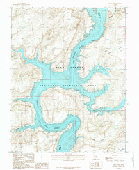
1987 Map of Hite South
USGS Topo · Published 1987About this map
Lake Colorado Powell River dominates this 1987 survey of the desert landscape at the border of Garfield and San Juan counties. Centered on the Glen Canyon National Recreation Area, the map documents the shoreline during the late twentieth century, showing the small settlement of Hite and its proximity to the boat ramp and the Browns Rim overlook.
Find a feature on this map
17 named features on this map. Tap any name to fly to it.
Don’t see what you’re looking for? This feature index may not catch every label — zoom into the map to look around manually.
Map Details
Editions of this 1987 Hite South Map
This is the sole edition of this map. No revisions or reprints were ever made.
Other maps of this area

1886 · Henry Mountains
USGS Topo · 1:250,000

1892 · Henry Mountains
USGS Topo · 1:250,000

1952 · Mancos Mesa
USGS Topo · 1:62,500

1952 · Mt Pennell 1 NE
USGS Topo · 1:24,000

1952 · Mt Hillers
USGS Topo · 1:62,500

1952 · Mt Pennell 1 SE
USGS Topo · 1:24,000

1952 · Hite
USGS Topo · 1:62,500

1953 · Mt Pennell 4 NE
USGS Topo · 1:24,000

1953 · Mt. Ellsworth
USGS Topo · 1:62,500
1954 · White Canyon 2 NE
USGS Topo · 1:24,000